
Drone bathymetry: shallow-water depth survey without a boat
Depth surveys of shallow water, without putting a boat on it.
Drone bathymetry measures water depth from a small unmanned platform that flies or tows a sonar over the surface. It reaches shallow, congested or hazardous water that survey vessels cannot, and it joins seamlessly with topographic data on the adjacent land.
Multibeam range; single-beam for the shallowest water.
RTK/PPK positioning on the drone.
No vessel needed to mobilise.
One dataset across the waterline.
What is drone bathymetry?
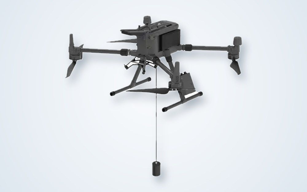
Drone bathymetry is the measurement of water depth using a sonar carried by an unmanned aircraft. The drone flies to the survey line, lowers a tethered echosounder into the water or settles a compact sonar on the surface, records depth and position together, and moves on to the next line.
Darkocean uses a DJI Matrice 400 with an SPH Engineering SkyHub onboard computer that logs the sonar and positioning data. For detailed seabed coverage the payload is a Cerulean Surveyor 240-16 multibeam echosounder, a 240 kHz instrument with a 16-element receive array working over roughly 0.5 to 50 m of range. For the very shallowest water and simple profiles, an ECT D052S single-beam echosounder is tethered below the drone.
Because the drone launches from the shore, there is no vessel to mobilise and no draft limit. That makes it practical for harbours full of moorings, intake channels, small reservoirs, lagoons, mine ponds and surf-zone edges. The same drone can also fly a topographic survey of the bank, so the land and underwater models share one datum.
It is not a replacement for a survey vessel everywhere. Open and deep water, strong currents, high waves and long offshore lines are better served by a boat, and flight time limits the area covered per battery.
How it works
Plan
Set accuracy, line spacing, tide and datum, check airspace and choose the sonar payload.
Fly
Fly the survey lines from the shore while the sonar logs depth with RTK or PPK position.
Process
Apply tide and sound-velocity corrections, clean the soundings and build the surface.
Deliver
Issue depth models, charts and a report, merged with land data where required.
What you receive
Mapping
a. Bathymetric surface (grid or TIN)
b. Depth contours and charts
c. Combined land and water model
Analysis
a. Volume and sedimentation change
b. Cross-sections and profiles
c. Slope and channel geometry
Reporting
a. Survey report with method and accuracy
b. Processed XYZ and raster files
c. Source data on request
Where it is used
Ports and harboursBerth pockets and approach channels where a vessel cannot manoeuvre safely.
DredgingPre- and post-dredge volumes and as-built checks in shallow work areas.
Coastal engineeringNearshore profiles and structure toe levels for defence and reclamation design.
Reservoirs and damsStorage capacity and sediment build-up in reservoirs and ponds.
Mining and tailingsPond and lagoon depths measured without placing crews on or near the water.
Intakes and outfallsSeabed condition around cooling-water and discharge structures.
Equipment we use
Drone or survey boat?
| Drone | Survey boat | |
|---|---|---|
| Mobilisation | Launch from the shore | Vessel, crew and launch site |
| Shallow water | Works in very shallow and obstructed water | Limited by draft |
| Depth and open water | Best in sheltered, shallow water | Suited to deep and open water |
| Area per day | Small to medium sites | Large areas and long lines |
Frequently asked questions
How accurate is drone bathymetry?
Position is centimetre-level with RTK or PPK. Depth accuracy depends on the sonar, sound-velocity and tide corrections and the water conditions, so the achieved figure is verified and reported for each survey.
Does turbid or murky water matter?
Not to a sonar. Acoustic depth measurement works in turbid water where optical and satellite methods fail. Heavy aeration, dense weed or strong stratification can affect results and are reviewed during planning.
How much can be surveyed in a day?
That depends on line spacing, depth, battery flight time and sea state. Drone survey suits small to medium sites; we give a realistic estimate once the area and accuracy requirement are known.
Can land and water be merged into one model?
Yes. The same drone can fly LiDAR or photogrammetry over the bank, and both datasets are tied to one datum so the surface is continuous across the waterline.
Need depths from water a boat cannot reach?
Send us the site and we will advise whether a drone, a vessel or a mix is the right fit.
